Mission Statement

Fort Bend County Levee Improvement District No. 6 (Fort Bend County LID 6), through the dedication of its Directors and Consultants, is committed to providing the highest quality of service at the most economical costs to its customers and taxpayers.

Hurricane Preparedness – Life-Saving Flood and Hurricane Safety Tips

Our LID 6 Hurricane video can be found below.  We had some mic problems and added an AI generated “closed captioning” to help when you can’t hear or understand the audio.  Sometimes the computer generated audio misses a word or two.  I apologize for the poor audio.  The powerpoint presentations by NOAA, the Fort Bend County Flood Control District, our LID 6 Engineer and Fort Bend County Homeland Security and Emergency Management are attached so you can see the slides in each presentation.

Presentations


Potential Upcoming Significant Rainfall

As you may be aware, local weather forecasts are currently projecting potentially significant rainfall in our region.  The LID 6 Board and operational team are closely monitoring the weather.  Recent models indicate the potential for anywhere from 3″ to as much as 12″ of total rainfall in the coming week, with potential bursts of intense rainfall in a short amount of time.  Thankfully, Brazos River levels are currently low, and the ground is dry and should be able to absorb rainfall efficiently, at least initially.

All LID 6 drainage facilities are fully operational and max capacity to accept the incoming rainfall.  Your levee management and operators are monitoring the situation very closely and will take appropriate actions to manage the situation to the best of our hardware capabilities.

We encourage all residents to monitor the local forecast and take appropriate precautions, such as moving any garbage cans and parked cars off of the street prior to projected rainfall, and to never drive into high water.

Attention: FEMA Risk Rating 2.0 (Flood Insurance Premiums)

Should you buy flood insurance or not if you live in Del Webb, Veranda or Williams Ranch?  That is a question that each homeowner must ask themselves.  Whether you already have it or are considering it, there is something that you need to know.

FEMA, the Federal Emergency Management Agency, is coming out with a new method of rating the flood risk of a property.  Their original method was with a product called Flood Insurance Rate Maps.  This methodology has not changed in over 50 years, but the change is coming, and it will go into effect October 1, 2021.  This new method called Risk Rating 2.0 utilizes the latest technology available to assess the flood risk of a property.

With Risk Rating 2.0, FEMA estimates that 14% of Texas residents with an existing flood insurance policy will see an immediate decrease in their flood insurance premium; 79% of Texas residents with an existing flood insurance policy will see an immediate increase in their flood insurance premium that could range from $0 to $10 per month; 3% of Texas residents with an existing flood insurance policy will see an immediate increase in their flood insurance premium of $10 to $20 per month; and 4% of Texas residents with an existing flood insurance policy will see an immediate increase in their flood insurance premium greater than $20 per month.

We do not yet know how Risk Rating 2.0 will impact flood insurance prices in Fort Bend LID 6.  We do not know which category of premium change will include us.  However, if you already have flood insurance, you are grandfathered into how fast your flood insurance premium can increase.  It is federally mandated that a flood insurance premium cannot increase by more than 18% per year.  Therefore, we encourage you to get flood insurance. Just contact your home insurance provider.  Since a flood insurance policy takes 30 days to go into effect, you must purchase your policy by September 1, 2021, for your policy to become effective prior to the effective date of Risk Rating 2.0.

Additional information regarding Risk Rating 2.0 can be found at Risk Rating 2.0: Equity in Action | FEMA.gov

Weather Update

Fort Bend Levee Improvement District No. 6 and Fort Bend County are planning on experiencing heavy rainfall over the next 24-48 hours. We are monitoring the situation and have personnel inspecting the drainage facilities. Please remove all trash cans from the street and check your outfall drains to make sure everything is clear. If you see significant street flooding, do not drive through it. Residents should monitor the Fort Bend County Office of Homeland Security and Emergency Management at https://fbcoem.org for up to date weather and flooding notices.

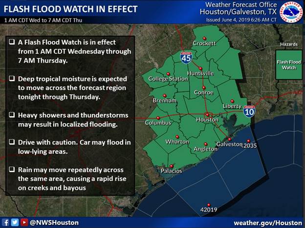
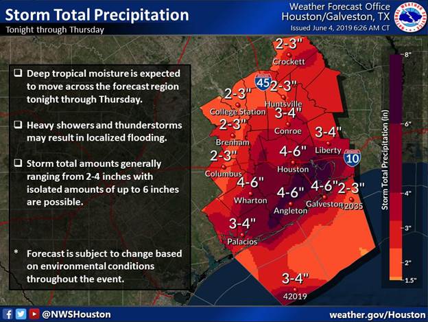
Severe Weather Update – 06/04/2019 @ 8 AM

Although the National Hurricane Center has reduced the development of Invest 91L to a 40% chance over the next 48 hours, this system will bring excess rainfall across the region over then next couple of days. Based on the conditions, the NWS will place our region, including Fort Bend County, in a Flash Flood Watch from 1 AM Wednesday to 7 AM Thursday.

Based on this morning’s forecast, the region could see widespread rainfall amounts between 2 to 4 inches with isolated totals up to 6 inches. Rainfall rates from this storm could reach 2 to 3 inches per hour which can cause rapid street flooding and creek rises in some areas. As stated by the NWS, these forecasts are subject to change due to the environmental conditions throughout the event. We will continue to monitor and provide updates when possible, but we encourage everyone to stay informed through the National Weather Service and Fort Bend County Office of Homeland Security & Emergency Management as changes in these forecast could occur within a relatively short period of time.